
By David Ponce
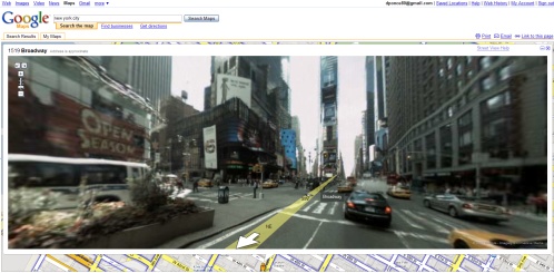
Google Maps just added a fascinating layer of data to its already impressive feature set. In select cities (New York, Las Vegas, San Francisco, Denver and Miami) it is now possible to get a viewpoint called “Steet View”, which allows you to get a street level 360 degree view of any point on that given map. In any of the above cities, just press on the “Street View” button, and a little humanoid appears. Drag him to any location on the map, and instantly a window appears with street level pictures. It’s possible to zoom within the picture, and rotate 360 degrees. And yes, we know it’s not the first such initiative, but Google’s implementation is elegant and flawless.
Google achieved this by getting teams in the Bay Area to drive around every single street for about a year, with special cameras mounted on board. The rest of the cities were mapped by contracting a company called Immersive Media. The above picture shows Times Square, but I must have wasted a good hour just checking out different neighborhoods and landmarks, and there’s no better way to kill a Thursday than by doing this. There may be plans to expand this to other major metropolitan centers at a later date.
[ Google Maps ] VIA [ Lost Remote ]


Kinda scary. Just like deja vu.
I don’t get the last sentence. Are there plans or aren’t they? What does that sentence even mean?