
 By Andrew Liszewski
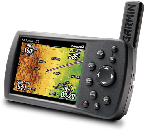
I’m sure these days a built-in GPS unit is an option for even the smallest of Cessna or Piper aircraft. But if your plane was taking to the skies well before GPS technology was available to the average consumer, you can retrofit it with this new Garmin unit specifically designed for flying. The GPSMAP 495 is actually a slightly more affordable version of Garmin’s GPSMAP 496 since it lacks the pre-loaded City Navigator NT database and real-time XM weather data. So basically if you also wanted to use the unit for navigating in a car or boat you’d have to manually load the city map or marine chart data for your location.
But it does include all the features you’ll need for flying like SafeTaxi airport diagrams, the AOPA airport directory, enhanced terrain warning, Smart Airspace and a database of private airports and heliports. The 495 also updates the map data and instruments at 5 Hz which is a significantly faster update rate providing an almost real-time presentation of the aircraft’s analog indicators. I have to assume all these features are a great thing to have since I never completed or even started flight school. (But I can fly through hoops in PilotWings on the SNES like you wouldn’t believe.)
The GPSMAP 495 will be available sometime in April for $1,595.
[ Garmin GPSMAP 495 ] VIA [ SlipperyBrick ]


We use the 496 in our Cessna, and it’s awesome, very easy to use. The price is prohibitive, though, and if the 495 was available a few years ago, I bet we’d have probably gone with it. The XM weather is cool, but it costs extra. The Smart Airspace feature alone probably justifies the price unless you’re flying out in the boonies.
The GPSMAP 495 is actually a slightly more affordable version of Garmin’s GPSMAP 496.